文章内容如有错误或排版问题,请提交反馈,非常感谢!
目前大部分O2O性质的服务(如外卖)都是以城市商圈未中心进行拓展的。在社区运营层面往往也需要商圈的信息,比如咸鱼的“鱼塘”也是基于商圈进行的运营。更加完善的商圈数据,无疑会更好的协助城市运营。由于商圈/商业区不像行政区一样有非常明确和标准的划分,所以到底每个平台使用的商圈都存在一定的差异。如何完善此部分基础数据。
以下为个人思考点。
通过百度地图获取商圈信息
百度地图API接口中提供了商圈信息,具体数据信息可从http://api.map.baidu.com/library/CityList/1.4/examples/CityList.html 获取。
数据抓取程序:
import requests
import json
import re
from sqlalchemy import create_engine
import pandas as pd
import time
from requests.adapters import HTTPAdapter

s = requests.Session()
s.mount('http://', HTTPAdapter(max_retries=3))
s.mount('https://', HTTPAdapter(max_retries=3))

engine = create_engine('sqlite:///baidu_geo.db')


def loads_jsonp(_jsonp):
    try:
        return json.loads(re.match(".*?({.*}).*", _jsonp, re.S).group(1))
    except:
        raise ValueError('Invalid Input')


def get_place(areacode=1, business_flag=0):
    url = "http://api.map.baidu.com/shangquan/forward/"
    payloads = {
        "qt": "sub_area_list",
        "ext": 1,
        "level": 1,
        "areacode": areacode,
        "business_flag": business_flag,
        "callback": "BMap._rd._cbk96826"
    }

    headers = {
        "Referer": "http://api.map.baidu.com/library/CityList/1.4/examples/CityList.html",
        "User-Agent": "Mozilla/5.0 (Windows NT 10.0; WOW64; Trident/7.0; rv:11.0) like Gecko"
    }

    r = s.get(url, params=payloads, headers=headers, timeout=5)
    print(r.url)

    data = loads_jsonp(r.text)
    #print(data)
    if data.get('content', []):
        sub_list = data['content'].get('sub', [])
    else:
        sub_list = []

    if sub_list:
        sub_list = data['content']['sub']
        for sub in sub_list:
            sub_place = {}
            sub_place['father_area_code'] = data['content']['area_code']
            sub_place['father_area_name'] = data['content']['area_name']
            sub_place['father_area_type'] = data['content']['area_type']
            sub_place['father_geo'] = data['content']['geo']
            sub_place['area_code'] = sub.get('area_code')
            sub_place['area_name'] = sub.get('area_name')
            sub_place['area_type'] = sub.get('area_type')
            sub_place['geo'] = sub.get('geo')
            sub_place['sup_business_area'] = sub.get('sup_business_area', 0)
            sub_place['business_geo'] = sub.get('business_geo', '')
            sub_place['business_type'] = sub.get('business_type', '')
            sub_place_list = []
            sub_place_list.append(sub_place)
            place_df = pd.DataFrame(sub_place_list)
            place_df.to_sql(con=engine, name='sub_place', if_exists='append', index=False)
            print(sub_place['area_name'])
            time.sleep(1)
            get_place(sub['area_code'], sub_place['sup_business_area'])


if __name__ == '__main__':
    get_place()
但抓取完数据后,发现百度地图存放的城市边界信息使用的是瓦片坐标,而非普通的经纬度坐标。为了让数据更有适用性,需要进行坐标转换:
1、通过JSSDK转换瓦片坐标
//以下是根据百度地图JavaScriptAPI破解得到百度坐标<->墨卡托坐标转换算法
private static double[] array1 = {75, 60, 45, 30, 15, 0};
private static double[] array3 = {12890594.86, 8362377.87, 5591021, 3481989.83, 1678043.12, 0};
private static double[][] array2 = {new double[]{-0.0015702102444, 111320.7020616939, 1704480524535203, -10338987376042340, 26112667856603880, -35149669176653700, 26595700718403920, -10725012454188240, 1800819912950474, 82.5}
, new double[]{0.0008277824516172526, 111320.7020463578, 647795574.6671607, -4082003173.641316, 10774905663.51142, -15171875531.51559, 12053065338.62167, -5124939663.577472, 913311935.9512032, 67.5}
, new double[]{0.00337398766765, 111320.7020202162, 4481351.045890365, -23393751.19931662, 79682215.47186455, -115964993.2797253, 97236711.15602145, -43661946.33752821, 8477230.501135234, 52.5}
, new double[]{0.00220636496208, 111320.7020209128, 51751.86112841131, 3796837.749470245, 992013.7397791013, -1221952.21711287, 1340652.697009075, -620943.6990984312, 144416.9293806241, 37.5}
, new double[]{-0.0003441963504368392, 111320.7020576856, 278.2353980772752, 2485758.690035394, 6070.750963243378, 54821.18345352118, 9540.606633304236, -2710.55326746645, 1405.483844121726, 22.5}
, new double[]{-0.0003218135878613132, 111320.7020701615, 0.00369383431289, 823725.6402795718, 0.46104986909093, 2351.343141331292, 1.58060784298199, 8.77738589078284, 0.37238884252424, 7.45}};
private static double[][] array4 = {new double[]{1.410526172116255e-8, 0.00000898305509648872, -1.9939833816331, 200.9824383106796, -187.2403703815547, 91.6087516669843, -23.38765649603339, 2.57121317296198, -0.03801003308653, 17337981.2}
, new double[]{-7.435856389565537e-9, 0.000008983055097726239, -0.78625201886289, 96.32687599759846, -1.85204757529826, -59.36935905485877, 47.40033549296737, -16.50741931063887, 2.28786674699375, 10260144.86}
, new double[]{-3.030883460898826e-8, 0.00000898305509983578, 0.30071316287616, 59.74293618442277, 7.357984074871, -25.38371002664745, 13.45380521110908, -3.29883767235584, 0.32710905363475, 6856817.37}
, new double[]{-1.981981304930552e-8, 0.000008983055099779535, 0.03278182852591, 40.31678527705744, 0.65659298677277, -4.44255534477492, 0.85341911805263, 0.12923347998204, -0.04625736007561, 4482777.06}
, new double[]{3.09191371068437e-9, 0.000008983055096812155, 0.00006995724062, 23.10934304144901, -0.00023663490511, -0.6321817810242, -0.00663494467273, 0.03430082397953, -0.00466043876332, 2555164.4}
, new double[]{2.890871144776878e-9, 0.000008983055095805407, -3.068298e-8, 7.47137025468032, -0.00000353937994, -0.02145144861037, -0.00001234426596, 0.00010322952773, -0.00000323890364, 826088.5}};
//百度坐标转墨卡托
private static PointF LatLng2Mercator(LatLngPoint p)
{
    double[] arr = null;
    double n_lat = p.Lat > 74 ? 74 : p.Lat;
    n_lat = n_lat< -74 ? -74 : n_lat;
    for (var i = 0; i< array1.Length; i++)
    {
        if (p.Lat >= array1[i])
        {
            arr = array2[i];
            break;
        }
    }
    if (arr == null)

    {
        for (var i = array1.Length - 1; i >= 0; i--)

        {
            if (p.Lat<= -array1[i])
            {
                arr = array2[i];
                break;
            }
        }
    }
    double[] res = Convertor(p.Lng, p.Lat, arr);
    return new PointF((float)res[0], (float)res[1]);
}

//墨卡托坐标转百度
private static LatLngPoint Mercator2LatLng(PointF p)
{
    double[] arr = null;
    PointF np = new PointF(Math.Abs(p.X), Math.Abs(p.Y));
    for (var i = 0; i< array3.Length; i++)

    {
        if (np.Y >= array3[i])
        {
            arr = array4[i];
            break;
        }
    }
    double[] res = Convertor(np.X, np.Y, arr);
    return new LatLngPoint(res[0], res[1]);
}
private static double[] Convertor(double x, double y, double[] param)
{
    var T = param[0] + param[1] * Math.Abs(x);
    var cC = Math.Abs(y) / param[9];
    var cF = param[2] + param[3] * cC + param[4] * cC * cC + param[5] * cC * cC * cC + param[6] * cC * cC * cC * cC + param[7] * cC * cC * cC * cC * cC + param[8] * cC * cC * cC * cC * cC * cC;
    T *= (x< 0 ? -1 : 1);
    cF *= (y< 0 ? -1 : 1);
    return new double[]{T, cF};
}
2、通过C#转换瓦片坐标
//以下是根据百度地图JavaScriptAPI破解得到百度坐标<->墨卡托坐标转换算法
private static double[] array1 = {75, 60, 45, 30, 15, 0};
private static double[] array3 = {12890594.86, 8362377.87, 5591021, 3481989.83, 1678043.12, 0};
private static double[][] array2 = {new double[]{-0.0015702102444, 111320.7020616939, 1704480524535203, -10338987376042340, 26112667856603880, -35149669176653700, 26595700718403920, -10725012454188240, 1800819912950474, 82.5}
, new double[]{0.0008277824516172526, 111320.7020463578, 647795574.6671607, -4082003173.641316, 10774905663.51142, -15171875531.51559, 12053065338.62167, -5124939663.577472, 913311935.9512032, 67.5}
, new double[]{0.00337398766765, 111320.7020202162, 4481351.045890365, -23393751.19931662, 79682215.47186455, -115964993.2797253, 97236711.15602145, -43661946.33752821, 8477230.501135234, 52.5}
, new double[]{0.00220636496208, 111320.7020209128, 51751.86112841131, 3796837.749470245, 992013.7397791013, -1221952.21711287, 1340652.697009075, -620943.6990984312, 144416.9293806241, 37.5}
, new double[]{-0.0003441963504368392, 111320.7020576856, 278.2353980772752, 2485758.690035394, 6070.750963243378, 54821.18345352118, 9540.606633304236, -2710.55326746645, 1405.483844121726, 22.5}
, new double[]{-0.0003218135878613132, 111320.7020701615, 0.00369383431289, 823725.6402795718, 0.46104986909093, 2351.343141331292, 1.58060784298199, 8.77738589078284, 0.37238884252424, 7.45}};
private static double[][] array4 = {new double[]{1.410526172116255e-8, 0.00000898305509648872, -1.9939833816331, 200.9824383106796, -187.2403703815547, 91.6087516669843, -23.38765649603339, 2.57121317296198, -0.03801003308653, 17337981.2}
, new double[]{-7.435856389565537e-9, 0.000008983055097726239, -0.78625201886289, 96.32687599759846, -1.85204757529826, -59.36935905485877, 47.40033549296737, -16.50741931063887, 2.28786674699375, 10260144.86}
, new double[]{-3.030883460898826e-8, 0.00000898305509983578, 0.30071316287616, 59.74293618442277, 7.357984074871, -25.38371002664745, 13.45380521110908, -3.29883767235584, 0.32710905363475, 6856817.37}
, new double[]{-1.981981304930552e-8, 0.000008983055099779535, 0.03278182852591, 40.31678527705744, 0.65659298677277, -4.44255534477492, 0.85341911805263, 0.12923347998204, -0.04625736007561, 4482777.06}
, new double[]{3.09191371068437e-9, 0.000008983055096812155, 0.00006995724062, 23.10934304144901, -0.00023663490511, -0.6321817810242, -0.00663494467273, 0.03430082397953, -0.00466043876332, 2555164.4}
, new double[]{2.890871144776878e-9, 0.000008983055095805407, -3.068298e-8, 7.47137025468032, -0.00000353937994, -0.02145144861037, -0.00001234426596, 0.00010322952773, -0.00000323890364, 826088.5}};
//百度坐标转墨卡托
private static PointF LatLng2Mercator(LatLngPoint p)
{
    double[] arr = null;
    double n_lat = p.Lat > 74 ? 74 : p.Lat;
    n_lat = n_lat< -74 ? -74 : n_lat;
    for (var i = 0; i< array1.Length; i++)
    {
        if (p.Lat >= array1[i])
        {
            arr = array2[i];
            break;
        }
    }
    if (arr == null)
    {
        for (var i = array1.Length - 1; i >= 0; i--)
        {
            if (p.Lat<= -array1[i])
            {
                arr = array2[i];
                break;
            }
        }
    }
    double[] res = Convertor(p.Lng, p.Lat, arr);
    return new PointF((float)res[0], (float)res[1]);
}

//墨卡托坐标转百度
private static LatLngPoint Mercator2LatLng(PointF p)
{
    double[] arr = null;
    PointF np = new PointF(Math.Abs(p.X), Math.Abs(p.Y));
    for (var i = 0; i< array3.Length; i++)
    {
        if (np.Y >= array3[i])
        {
            arr = array4[i];
            break;
        }
    }
    double[] res = Convertor(np.X, np.Y, arr);
    return new LatLngPoint(res[0], res[1]);
}
private static double[] Convertor(double x, double y, double[] param)
{
    var T = param[0] + param[1] * Math.Abs(x);
    var cC = Math.Abs(y) / param[9];
    var cF = param[2] + param[3] * cC + param[4] * cC * cC + param[5] * cC * cC * cC + param[6] * cC * cC * cC * cC + param[7] * cC * cC * cC * cC * cC + param[8] * cC * cC * cC * cC * cC * cC;
    T *= (x< 0 ? -1 : 1);
    cF *= (y< 0 ? -1 : 1);
    return new double[]{T, cF};
}
3、通过JAVA转换瓦片坐标
public class LngLat {
private double longitude; //经度
private double lantitude; //维度

public LngLat() {
}

public LngLat(double longitude, double lantitude) {
this.longitude = longitude;
this.lantitude = lantitude;
}

public double getLongitude() {
return longitude;
}

public void setLongitude(double longitude) {
this.longitude = longitude;
}

public double getLantitude() {
return lantitude;
}

public void setLantitude(double lantitude) {
this.lantitude = lantitude;
}

@Override
public String toString() {
return "LngLat{" +
"longitude=" + longitude +
", lantitude=" + lantitude +
'}';
}
}
public class CoodinateCovertor {
    private static Double EARTH_RADIUS = 6370996.81;
    private static Double[] MCBAND = {12890594.86, 8362377.87, 5591021d, 3481989.83, 1678043.12, 0d};
    private static Double[] LLBAND = {75d, 60d, 45d, 30d, 15d, 0d};
    private static Double[][] MC2LL = {{1.410526172116255e-8, 0.00000898305509648872, -1.9939833816331, 200.9824383106796, -187.2403703815547, 91.6087516669843, -23.38765649603339, 2.57121317296198, -0.03801003308653, 17337981.2}, {-7.435856389565537e-9, 0.000008983055097726239, -0.78625201886289, 96.32687599759846, -1.85204757529826, -59.36935905485877, 47.40033549296737, -16.50741931063887, 2.28786674699375, 10260144.86}, {-3.030883460898826e-8, 0.00000898305509983578, 0.30071316287616, 59.74293618442277, 7.357984074871, -25.38371002664745, 13.45380521110908, -3.29883767235584, 0.32710905363475, 6856817.37}, {-1.981981304930552e-8, 0.000008983055099779535, 0.03278182852591, 40.31678527705744, 0.65659298677277, -4.44255534477492, 0.85341911805263, 0.12923347998204, -0.04625736007561, 4482777.06}, {3.09191371068437e-9, 0.000008983055096812155, 0.00006995724062, 23.10934304144901, -0.00023663490511, -0.6321817810242, -0.00663494467273, 0.03430082397953, -0.00466043876332, 2555164.4}, {2.890871144776878e-9, 0.000008983055095805407, -3.068298e-8, 7.47137025468032, -0.00000353937994, -0.02145144861037, -0.00001234426596, 0.00010322952773, -0.00000323890364, 826088.5}};
    private static Double[][] LL2MC = {{-0.0015702102444, 111320.7020616939, 1704480524535203d, -10338987376042340d, 26112667856603880d, -35149669176653700d, 26595700718403920d, -10725012454188240d, 1800819912950474d, 82.5}, {0.0008277824516172526, 111320.7020463578, 647795574.6671607, -4082003173.641316, 10774905663.51142, -15171875531.51559, 12053065338.62167, -5124939663.577472, 913311935.9512032, 67.5}, {0.00337398766765, 111320.7020202162, 4481351.045890365, -23393751.19931662, 79682215.47186455, -115964993.2797253, 97236711.15602145, -43661946.33752821, 8477230.501135234, 52.5}, {0.00220636496208, 111320.7020209128, 51751.86112841131, 3796837.749470245, 992013.7397791013, -1221952.21711287, 1340652.697009075, -620943.6990984312, 144416.9293806241, 37.5}, {-0.0003441963504368392, 111320.7020576856, 278.2353980772752, 2485758.690035394, 6070.750963243378, 54821.18345352118, 9540.606633304236, -2710.55326746645, 1405.483844121726, 22.5}, {-0.0003218135878613132, 111320.7020701615, 0.00369383431289, 823725.6402795718, 0.46104986909093, 2351.343141331292, 1.58060784298199, 8.77738589078284, 0.37238884252424, 7.45}};

    private static double x_pi = 3.14159265358979324 * 3000.0 / 180.0;

    /**
    * 墨卡托坐标转经纬度坐标
    *
    * @param x
    * @param y
    * @return
    */
    public static Map convertMC2LL(Double x, Double y) {
        Double[] cF = null;
        x = Math.abs(x);
        y = Math.abs(y);
        for (int cE = 0; cE< MCBAND.length; cE++) {
            if (y >= MCBAND[cE]) {
                cF = MC2LL[cE];
                break;
            }
        }
        Map location = converter(x, y, cF);
        location.put("lng", location.get("x"));
        location.remove("x");
        location.put("lat", location.get("y"));
        location.remove("y");
        return location;
    }

    private static Map converter(Double x, Double y, Double[] cE) {
        Double xTemp = cE[0] + cE[1] * Math.abs(x);
        Double cC = Math.abs(y) / cE[9];
        Double yTemp = cE[2] + cE[3] * cC + cE[4] * cC * cC + cE[5] * cC * cC * cC + cE[6] * cC * cC * cC * cC + cE[7] * cC * cC * cC * cC * cC + cE[8] * cC * cC * cC * cC * cC * cC;
        xTemp *= (x< 0 ? -1 : 1);
        yTemp *= (y< 0 ? -1 : 1);
        Map location = new HashMap();
        location.put("x", xTemp);
        location.put("y", yTemp);
        return location;
    }

    /**
    * 对double类型数据保留小数点后多少位
    * 高德地图转码返回的就是小数点后6位,为了统一封装一下
    *
    * @param digit 位数
    * @param in 输入
    * @return 保留小数位后的数
    */
    static double dataDigit(int digit, double in) {
        return new BigDecimal(in).setScale(6, BigDecimal.ROUND_HALF_UP).doubleValue();
    }

    /**
    * 将火星坐标转变成百度坐标
    *
    * @param lngLat_gd 火星坐标(高德、腾讯地图坐标等)
    * @return 百度坐标
    */

    public static LngLat bd_encrypt(LngLat lngLat_gd) {
        double x = lngLat_gd.getLongitude(), y = lngLat_gd.getLantitude();
        double z = sqrt(x * x + y * y) + 0.00002 * sin(y * x_pi);
        double theta = atan2(y, x) + 0.000003 * cos(x * x_pi);
        return new LngLat(dataDigit(6, z * cos(theta) + 0.0065), dataDigit(6, z * sin(theta) + 0.006));
    }/**
* 将百度坐标转变成火星坐标
*
* @param lngLat_bd 百度坐标(百度地图坐标)
* @return 火星坐标(高德、腾讯地图等)
*/
static LngLat bd_decrypt(LngLat lngLat_bd) {
    double x = lngLat_bd.getLongitude() - 0.0065, y = lngLat_bd.getLantitude() - 0.006;
    double z = sqrt(x * x + y * y) - 0.00002 * sin(y * x_pi);
    double theta = atan2(y, x) - 0.000003 * cos(x * x_pi);
    return new LngLat(dataDigit(6, z * cos(theta)), dataDigit(6, z * sin(theta)));
}

// 测试代码
public static void main(String[] args) {
    Map<String, Double> map = convertMC2LL(Double.parseDouble("13374519.1263999"), Double.parseDouble("3519753.77716"));
    System.out.println("百度坐标:" + map);
    Double lng = map.get("lng");
    Double lat = map.get("lat");
    LngLat lngLat_bd = new LngLat(lng, lat);
    System.out.println("高德坐标:" + bd_decrypt(lngLat_bd));
}
}
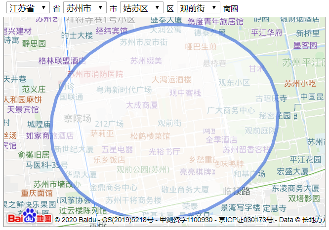
关于此部分数据个人的看法:百度的商圈范围非常的小,基本上不包含辐射范围。很难应用到一些辐射性场景。
通过高德获取AOI数据
POI和AOI的区别:
- POI(point of interest),即在线地图检索的对象之一"兴趣点"。
- AOI(area of interest),即信息面,也叫兴趣面。指的是地图数据中的区域状的地理实体
高德获取AOI边界的方式:https://ditu.amap.com/detail/get/detail?id=XXXX
id对应的是高德的aoi编号,而这个AOI编号和POI编号是一致的。知道以上信息就可以针对性的抓取特定的AOI边界信息。
通过外卖平台商户位置生成商圈信息
POI与AOI的思考
在商圈实际使用的过程中,往往对POI和AOI如何进行划分没有明确的界限。同一个点可以是POI也可以是AOI。单遇到搜索场景时就会不清楚是按POI还是AOI召回?
我的想法:
- 哪些场景适合使用POI,哪些场景适合AOI
- 对AOI进行面积计算(太大或者太小都不合适)
- 面积较大的POI适合作为AOI,比如:黄山、西湖、春熙路..
- 同一类型POI也存在差异,以大学为例,有的大学面积非常大,有的这非常的小
- 对AOI进行面积计算(太大或者太小都不合适)
- 什么时候用POI什么时候AOI?
- 当类POI半径<POI召回半径时,建议使用POI
- 当类POI半径>POI召回半径时,建议使用AOI